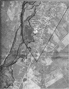
The new Flood Insurance Rate Maps for Franklin show the reach of the Special Flood Hazard Zone (a.k.a flood plain) according to the Flood Damage Prevention Law, passed at the April Town Board meeting as Local Law 2012-1. Our one flood plain extends from the East Sidney Reservoir up the Ouleout Creek to just above Chamberlin Hill Road, up Treadwell Creek as far as Jackson Hill Road, and up Handsome Brook as far as the fork of East Branch and West Branch.
This plain is defined as having a one percent chance each year of being flooded to deeper than one foot, and it marks what is commonly known as a hundred-year flood plain. (The span between the last two hundred-year floods in this plain was 51 years – August 1955 to June 2006.) This 2012 flood plain covers more land than the older version and allows more landowners to get subsidized flood insurance. At its widest, above the reservoir, our flood plain is over 3,000 feet across.
These maps mark the boundaries in greater detail than the old maps, which date from 1987, 25 years ago. Because of this detail, ten maps are needed to cover the flood plain in Franklin at a scale of 1”=500’ or 1”=1000’. The more detailed maps are for the area around the Village.
These federal maps (Exhibit 2) are available for viewing at the Town Hall, as is the accompanying report: Flood Insurance Study, Delaware County, New York, All Jurisdictions, Volumes 1 to 3. The report runs only 76 pages, but the accompanying flood profiles (Exhibit 1) run 163 pages. None of these profiles are for flooding in Franklin.
Construction within the flood plain must follow specific codes, and the plans require a Flood Plain Development Permit. Our code enforcement officer has been appointed the Local Flood Plain Administrator. Our new law adds a fee of $5 for this review, whereas Walton set their fee at $150.
The ordinance was written by the Delaware County Planning Department. Franklin passed the minimal version of the law (as recommended by Planning), unlike towns such as Hancock. Therefore our code enforcement officer will not be required to inventory all existing buildings in the flood plain. At the April meeting, Duncan Martin of the Delaware County Planning Department answered questions.
Unless the minimum was adopted, Franklin would not have been eligible for FEMA reimbursement and landowners would not have been eligible for the National Flood Insurance program. All of the flood plain in Franklin is zone A. New maps and fee went into effect June 19th.
